Getting trapped by the tide on a coastal trail is a preventable terror, born from a simple but critical misunderstanding of the ocean’s relentless power.
- True safety is not about avoiding the coast but about learning to read its environmental cues—tides, cliffs, and weather—like a seasoned expert.
- Your gear and your emergency plan are your crucial last lines of defense, not your primary strategy for a safe trek.
Recommendation: Shift your mindset from a race against the tide to a dance with its rhythm. The key is building a generous time buffer into every coastal plan.
The salt spray on your face, the cry of gulls overhead, and the endless blue horizon—coastal hiking offers some of the most dramatic and rewarding experiences in nature. But the same forces that carve these beautiful landscapes pose a unique and serious threat. Every year, hikers find themselves in the one place they should never be: the entrapment zone, caught between an impassable cliff and a relentlessly rising tide. Many guides will simply tell you to “check the tide times,” but this advice barely scratches the surface of the skills you need.
True coastal safety isn’t a checklist; it’s an art. It’s the art of synchronizing your personal rhythm with the ocean’s non-negotiable schedule. It involves reading the story told by sedimentary rock layers, understanding the language of the wind, and respecting the deceptive speed of incoming fog. This isn’t about fear. It is about deep respect and proactive knowledge. This guide moves beyond the basics to teach you the mindset of a coastal navigator, focusing on timing, observation, and understanding the powerful forces at play.
We will explore the fundamental rhythm of the tides, the silent dangers of the cliffs, and the atmospheric threats that can change your world in minutes. We’ll cover the gear that truly matters when traction is everything and discuss what to do if the worst happens. Finally, we’ll delve into deeper principles of water safety that inform a true expert’s understanding of the coast. By the end, you won’t just be a hiker; you’ll be a student of the coast’s rhythm.
This guide is structured to build your knowledge from the ground up, from fundamental principles to advanced survival concepts. Explore the sections below to master the art of coastal trekking.
Summary: A Guide to Coastal Hiking Safety and Tide Management
- High Tide vs Low Tide: How to Interpret Charts for Safe Beach Crossings?
- Why You Should Never Stand on the Edge of a Sedimentary Cliff?
- Fog and Wind: How to Navigate When the Coast Disappears in Minutes?
- Approach Shoes or Hiking Boots: What Grips Best on Slippery Algae?
- Whistle or Flare: What Works Best When Trapped at the Base of a Cliff?
- The Fetch Effect: Why Waves are Bigger in the Middle of the Lake?
- Wetsuit Thickness: How to Prevent Cold Shock on Spring Runoff Rivers?
- Canoeing Glacial Lakes: How to Survive a Capsize in Freezing Water?
High Tide vs Low Tide: How to Interpret Charts for Safe Beach Crossings?
The tide is the absolute, unyielding clock of the coast. Misunderstanding it is the single most common reason hikers get into trouble. In fact, research shows that a surprising 15% of the UK public have been cut off by the tide at least once. Interpreting a tide chart is more than just noting the times for high and low water; it’s about understanding the entire six-hour cycle of its rise and fall. The tide moves fastest during the middle of its cycle (the third and fourth hours) and slowest at the very beginning and end. This is known as the “Rule of Twelfths,” an expert-level concept that helps you estimate water level changes hour by hour.
When planning a beach crossing, your goal is not simply to “beat” the high tide. Your goal is to create a significant time buffer. Identify the section you need to cross on a map and find a tide chart for that specific location. Note the time and height of the next low tide and the following high tide. Your crossing should be planned around low tide, and you must be completely clear of the area well before the tide begins its rapid ascent. A good rule of thumb is to be off any questionable beach section at least three hours before the published high tide time.
Look for environmental cues. A wide, wet beach far from the current water line is a clear sign of how far the water will come. Observe the “strandline”—the line of seaweed and debris left at the last high tide mark. This is your absolute danger line. Never set up camp or rest below this line. Your safety depends on treating the tide not as a single event, but as a powerful, continuous process—the very breath of the ocean.
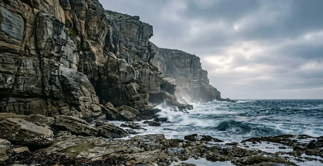
Why You Should Never Stand on the Edge of a Sedimentary Cliff?
Coastal cliffs may look like solid, permanent fixtures, but many are geological works-in-progress, especially those made of sedimentary rock. These cliffs are formed from layers of sand, silt, and clay compressed over millennia. They are inherently unstable, not because they are weak, but because they are composed of different layers with varying permeability and strength. Water from rainfall is their greatest enemy. It soaks into porous upper layers, like sandstone, but gets stopped by harder, non-porous layers like shale below. This creates immense hydrostatic pressure and lubricates the boundary between layers, making a catastrophic collapse not a matter of ‘if’, but ‘when’.
The most terrifying aspect of a sedimentary cliff collapse is its unpredictability. It can happen on a perfectly sunny day with no warning signs. The edge you are standing on may look solid, but the ground ten feet below it could be the failure point. The cardinal rule is simple: stay away from the edge, both at the top and at the base. At the top, a safe distance is at least the height of the cliff. If the cliff is 50 feet high, stay at least 50 feet back. At the base, avoid resting or picnicking directly underneath them.
Case Study: The Encinitas Cliff Collapse
In 2019, a tragic incident along the California coast in Encinitas highlighted this danger in the most devastating way. Three people were killed when a large section of the sedimentary sea cliff suddenly detached and fell onto the beach below. Subsequent analysis by geologists from the Scripps Institution of Oceanography revealed the classic mechanism: porous upper sandstone layers saturated by water slid off a more compact, 45-million-year-old rock layer beneath. The event occurred without any obvious, immediate trigger like an earthquake, serving as a stark reminder of the inherent instability of these formations.
This illustration of sedimentary layers reveals the hidden weaknesses within a coastal cliff, where erosion and water infiltration create fracture lines that can lead to sudden collapse.
As you can see, the intricate layers are not a sign of strength but of potential separation points. Each line represents a different moment in geological time and a different vulnerability to the forces of water and gravity. Respecting these forces means giving the cliffs a very wide berth.
Fog and Wind: How to Navigate When the Coast Disappears in Minutes?
On the coast, weather is a three-dimensional force. You must contend not only with rain but also with wind and fog, which can transform a pleasant hike into a disorienting survival situation in minutes. Sea fog, or advection fog, forms when warm, moist air moves over a cold sea surface. It can roll in with shocking speed, reducing visibility from miles to mere feet. As the Passagemaker Maritime Navigation Guide notes, the danger of fog is not just visual but psychological.
Fog is insidious in how it impairs your senses and perception. The most immediate impact of fog is the drastic reduction in visibility, which can range from a slight blur of the horizon to a complete whiteout.
– Passagemaker Maritime Navigation Guide, Boating in Fog: Navigation Tips for Safe Foggy Cruising
When fog descends, your world shrinks and your senses can betray you. The sound of the surf becomes your only compass, but it can also be misleading, echoing off unseen cliff faces. Wind is another critical factor. An onshore wind (blowing from sea to land) will push the tide in faster and higher than predicted, shortening your safety window. It can also amplify the power of waves. A strong offshore wind, while it might seem to help keep the water at bay, can make footing treacherous on exposed headlands. Your best defense is a modern GPS device or a reliable navigation app on your phone (with pre-downloaded maps), but you must also carry and know how to use a physical map and a baseplate compass. Technology fails; a magnetized needle does not.
If you are caught in a whiteout, the bravest and smartest thing to do is to stop. Find a safe spot, well away from any cliff edge and above the high tide line, and wait. Attempting to navigate through thick fog in unfamiliar territory is a recipe for disaster. Listen to the environment, stay warm, and be patient. The coast demands patience above all else.
Approach Shoes or Hiking Boots: What Grips Best on Slippery Algae?
Your only connection to the earth on a coastal trail is through the soles of your footwear. On a jagged, often wet, and algae-covered shoreline, that connection is tenuous and absolutely critical. The debate between approach shoes and hiking boots is nuanced, but it boils down to a trade-off between grip, support, and durability. That slick-looking film of green or black algae on coastal rocks has a friction coefficient similar to wet ice, making your choice of sole compound the most important gear decision you’ll make.
Hiking boots offer superior ankle support, which is invaluable on uneven terrain and for carrying a pack. Their stiffer soles protect your feet from sharp rocks. However, not all boot soles are created equal. Approach shoes, a hybrid of hiking shoes and climbing shoes, often feature “sticky” rubber compounds designed for superior grip on rock. This makes them excellent for scrambling, but the rubber is typically softer and wears out faster. For coastal hiking, the ideal footwear often has the support of a boot but with a sole made from a specialized, high-friction rubber compound designed for wet conditions.
The table below, based on data from expert reviews, compares some of the leading sole compounds for performance on the exact kind of wet, treacherous surfaces you’ll encounter on a coastal trail.
| Sole Compound | Wet Rock Grip | Durability | Best Use Case |
|---|---|---|---|
| Vibram Megagrip | Excellent | Moderate | Wet and dry surfaces, waterfalls, coastal trails |
| Stealth Rubber (C4) | Superior | Low (wears quickly) | Technical approach, slick rock scrambling |
| Standard Vibram (TC5+) | Fair | High | Dry technical terrain, struggles in wet/muddy conditions |
| Salomon Contragrip | Good | Moderate-High | Mixed terrain, wet traction with reasonable durability |
| Michelin Rubber | Very Good | High | Wet, rocky, and muddy surfaces with longevity |
As this analysis of hiking boot soles shows, choosing a boot with a compound like Vibram Megagrip or a proprietary equivalent can make a world of difference. No matter the shoe, always test your footing. Assume every dark, wet-looking rock is slippery until proven otherwise. Move deliberately, maintaining three points of contact whenever scrambling.
Whistle or Flare: What Works Best When Trapped at the Base of a Cliff?
Even with perfect planning, the unpredictable nature of the coast means you must be prepared for the worst-case scenario: you are trapped. The tide is coming in, you have no route of escape, and you need to signal for help. Your phone likely has no service. This is when your preparation and the simple tools in your pack become lifelines. The choice between signaling devices like a whistle or a flare depends on the conditions: day or night, fog or clear skies. The reality is you should carry both.
A high-decibel whistle is your most reliable and enduring signaling tool. It’s lightweight, waterproof, and its sound carries much farther than a human voice, especially over the roar of the surf. The international distress signal is three short blasts, repeated at one-minute intervals. A signal mirror is an excellent daytime tool in clear conditions, capable of flashing a beam of light that can be seen for miles. Flares provide the most powerful visual signal, especially at night or in overcast weather, but they are single-use and must be handled with care. A personal locator beacon (PLB) is the ultimate safety net; when activated, it transmits your GPS coordinates directly to search and rescue services.
Being trapped by the tide is a terrifyingly common emergency. In the British Isles alone, tidal cut-offs have resulted in around 3,600 rescues by the Royal National Lifeboat Institution since 2020. If you find yourself in this situation, your actions in the first 15 minutes are critical.
Action Plan: First 15-Minute Entrapment Protocol
- Secure Position & Assess: Immediately move to the highest, most visible point you can safely reach. Assess the tide’s speed and direction to estimate your time.
- Call for Help: If you have any mobile signal, call the emergency number for your location (e.g., 999 for Coastguard in the UK, 911 in the US) and state your precise location.
- Deploy Signals: Begin using your whistle (three short blasts). If it’s daytime and clear, use your signal mirror. Prepare your flare or strobe for when a potential rescuer is sighted or darkness falls.
- Conserve Heat & Energy: Get out of the wind as much as possible. Huddle to conserve body heat and avoid contact with cold water. Stay calm and resist the urge to attempt a risky swim.
- Activate Beacon: If you have a Personal Locator Beacon (PLB), this is the moment to activate it. Follow its instructions exactly. This is your most definitive call for help.
The Fetch Effect: Why Waves are Bigger in the Middle of the Lake?
As a coastal guide, I borrow wisdom from all water disciplines. A concept well-known to Great Lakes sailors is essential for understanding coastal wave behavior: the fetch effect. “Fetch” is the term for the distance of open water over which wind can blow without obstruction. The longer the fetch, the more energy is transferred from the wind to the water, resulting in larger, more powerful waves. This explains why waves are often bigger in the middle of a large lake, as the wind has had miles of open water to build them up.
How does this apply to coastal hiking? The fetch on the open ocean is immense, measured in hundreds or thousands of miles. This is why a perfectly calm, sunny day on your trail can still feature massive, powerful swells crashing on the shore. These waves, known as groundswells, were generated by a storm system hundreds of miles away, days ago. They have traveled across the vast fetch of the ocean, accumulating and conserving energy. They are a powerful reminder that what you see locally is not the full story.
Understanding the fetch effect changes your perception. You stop judging wave size based only on the local wind. You develop a deeper respect for any wave that reaches the shore, knowing the incredible journey and power it may contain. It teaches you to be wary of “sneaker waves”—individual waves that are much larger than the average, which can surge far up the beach and pull unsuspecting hikers into the sea. This principle reinforces the core rule of coastal safety: never turn your back on the ocean.
Wetsuit Thickness: How to Prevent Cold Shock on Spring Runoff Rivers?
Again, we turn to another group of water experts—whitewater paddlers—for a critical survival concept: cold shock. Paddlers meticulously choose wetsuit thickness to protect against the life-threatening effects of immersion in cold water. While you are hiking, not paddling, the risk of an accidental fall from a slippery rock into a cold Pacific or North Atlantic rock pool is real. Understanding the body’s reaction to cold water is not an academic exercise; it’s vital survival knowledge.
Cold shock is the body’s involuntary and overwhelming response to sudden immersion in water colder than 60°F (15°C). It begins with an uncontrollable gasp for air, followed by hyperventilation. If your head is underwater during this initial gasp, drowning is almost instantaneous. This initial phase lasts for about one minute and is the most dangerous part of cold water immersion. It has nothing to do with swimming ability; it is a physiological reflex.
Why is this relevant to a hiker? It reframes your risk assessment. A simple slip and fall into the water is not just a matter of getting wet; it’s a potentially fatal event. It instills a profound respect for staying dry. It’s why you test every footstep on wet rocks. It’s why you give a wide berth to surging surf channels. While you won’t be wearing a wetsuit, the knowledge of why a paddler needs one provides a powerful lesson in prevention. Your “wetsuit” is your vigilance, your sturdy footwear, and your deliberate, careful movement along the water’s edge.
Key Takeaways
- The tide is a continuous process; your safety depends on understanding its six-hour cycle, not just the high and low points.
- Sedimentary cliffs are inherently unstable. Your distance from the edge, both top and bottom, should be at least equal to the cliff’s height.
- Your primary navigation tools are a map and compass, backed up by GPS. In fog, sound and patience become your best guides.
Canoeing Glacial Lakes: How to Survive a Capsize in Freezing Water?
We end with the most extreme scenario, drawing wisdom from those who navigate the world’s coldest waters. The principles of surviving a capsize in a glacial lake offer the definitive lesson in managing the final, and most enduring, threat of cold water: hypothermia. If the initial cold shock doesn’t kill you, the progressive cooling of your body’s core will. For a coastal hiker swept into the ocean, understanding this process is the key to extending survival time until rescue arrives.
The most important concept to grasp is the 1-10-1 Principle of cold water immersion. It is a simple but powerful mnemonic for survival:
- 1 Minute: You have about one minute to get your breathing under control. The cold shock response will cause you to hyperventilate. You must fight this, stay calm, and avoid panic. Do not try to swim during this minute; just focus on breathing and keeping your airway clear of the water.
- 10 Minutes: You have approximately ten minutes of meaningful, controlled movement. Your muscles and nerves will be rapidly cooled, and you will lose dexterity. This is your critical window to attempt self-rescue, like getting onto a floating object or back onto a rock. After 10 minutes, you will be unable to perform these tasks.
- 1 Hour: It can take up to an hour before you lose consciousness due to hypothermia. After you’ve lost meaningful movement, your job is to conserve energy and heat. Assume a heat-conserving posture (Heat Escape Lessening Posture, or H.E.L.P., pulling your knees to your chest) and keep your head out of the water. This hour is the window for rescuers to find you.
This knowledge is sobering, but it is also empowering. It replaces panic with a plan. It tells you that even in the freezing ocean, you have time if you know what to do. It reinforces the importance of your signaling devices and a PLB, as they are your call for help during that precious one-hour window. It is the final, stark lesson from the world of water safety: respect the cold, have a plan, and understand the clock is always ticking.
Your journey along the coast is a partnership with the environment. By learning its rhythms, respecting its power, and preparing for its challenges, you transform a potentially hazardous trek into one of life’s most profound and beautiful adventures. The next step is to apply this knowledge by planning a small, safe coastal walk using these principles.