Relying on common myths like “moss grows on the north side” is a recipe for disaster in a boreal forest; true navigation comes from skilled observation.
- Technology is fallible, and dense canopies or remote logging roads will defeat standard GPS systems.
- Survival depends on practical skills: finding water through vegetation, moving efficiently to conserve energy, and choosing a safe campsite by reading tree health.
Recommendation: Before your next trip, shift your focus from relying solely on a device to actively practicing landscape literacy—learn to read the subtle but reliable clues the forest provides.
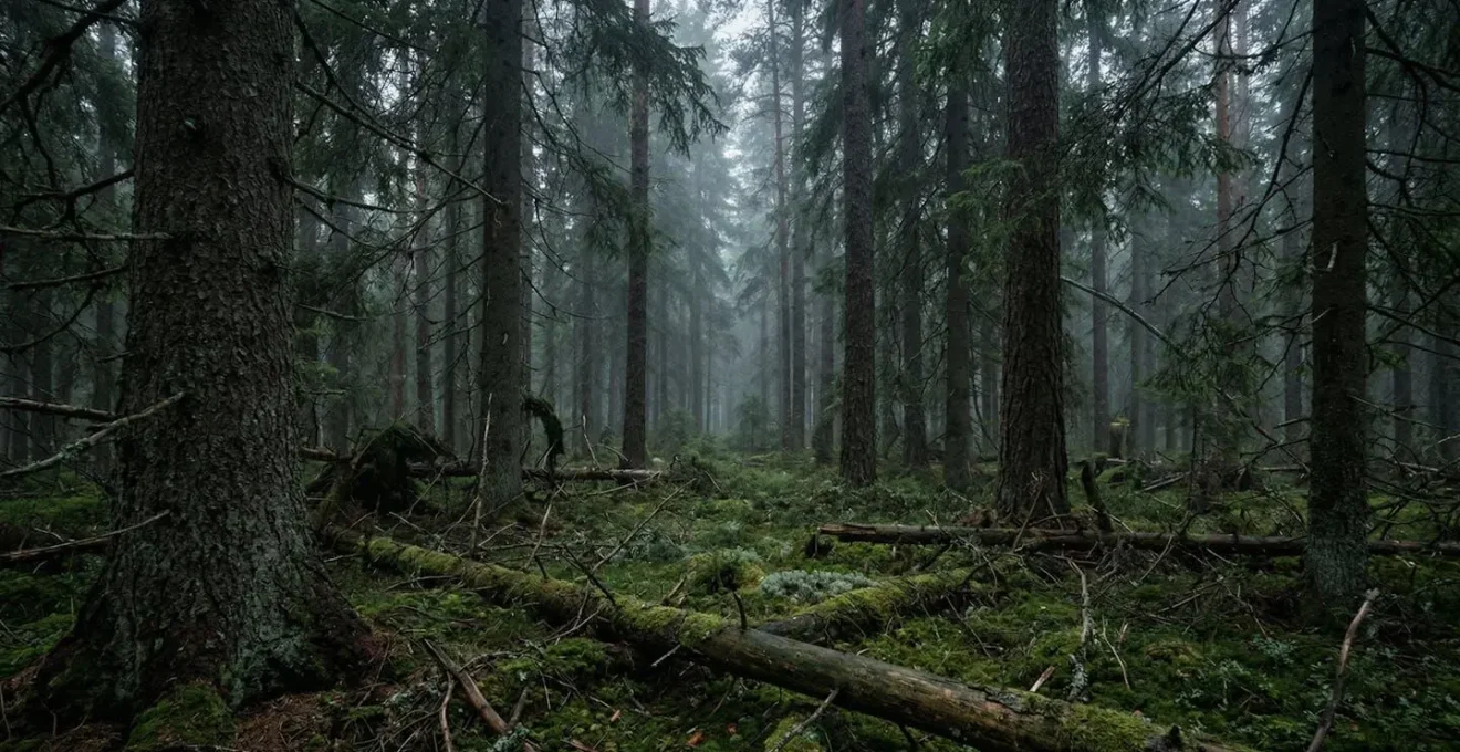
The thought of a GPS blinking out in the heart of a vast, featureless boreal forest is a chilling one for any trekker. In these ancient woodlands of Canada or Scandinavia, the canopy can be so dense that the sky disappears, and every direction looks the same. The common advice—look for moss on trees, follow the sun—often falls apart in the complex reality of a forest floor shrouded in shadow and damp. These tricks are platitudes, offering a fragile sense of security that can vanish with the first wrong turn.
This isn’t a guide about downloading another app. It’s about cultivating a deeper awareness, a skill set that predates any satellite. The core principle is not about memorizing a list of tips, but about developing landscape literacy. It’s the ability to read the subtle language of the environment to build a reliable mental map when your digital one is blank. This means understanding why a certain plant grows where it does, how to move with an awareness of your body’s energy economy, and how to interpret the difference between a natural pattern and a dangerous anomaly.
We will deconstruct the myths and replace them with reliable, observable facts. We’ll cover how to move through the wilderness without exhausting yourself, how to identify hidden hazards, and how to find life-sustaining resources. Finally, we’ll address the limitations of modern technology and how to prepare it properly as a backup, not a primary tool. This is your foundation for navigating with confidence, using the most powerful tool you have: your own observation.
This article provides a structured approach to mastering these essential survival skills. The following sections break down key challenges you’ll face in a boreal forest and offer practical, field-tested solutions to overcome them.
Table of Contents: A Guide to Off-Grid Forest Navigation
- Why Moss Doesn’t Always Grow on the North Side of Trees?
- How to Move Through Dense Undergrowth Without Exhausting Yourself in 1 Hour?
- Root Systems and Widowmakers: Where Not to Pitch Your Tent in Old Growth?
- Stagnant vs Flowing: How to Locate Safe Water When You Can’t See a River?
- Wolf or Dog: How to Identify Fresh Tracks in Pine Needles?
- Order in Chaos: How to Find a Subject in a Messy Forest Scene?
- Offline GPS: Why Google Maps Fails on Logging Roads?
- Using Satellite Navigation: How to Pre-Load Maps for Offline Use?
Why Moss Doesn’t Always Grow on the North Side of Trees?
One of the most pervasive and dangerous navigation myths is that moss reliably indicates north. This oversimplification can lead a disoriented hiker in the exact wrong direction. The reality is that moss isn’t a compass; it’s a moisture indicator. In a dense boreal forest, moisture is everywhere. It’s retained in the bark, trapped by the humid air under the canopy, and drips down from overlapping branches. The truth is that moss grows on any surface where moisture is retained, regardless of cardinal direction. You’ll often find it growing all around a tree trunk or in patches dictated by bark texture and localized shade, not the sun’s path.
Relying on this fallacy is a critical error in judgment. A far more reliable method for determining direction is using the sun’s shadow, even on an overcast day when a faint shadow is still cast. The shadow-stick method is a classic and accurate survival technique. By marking the tip of a stick’s shadow and then marking it again 15-20 minutes later, you create a line from the first mark (West) to the second (East). This simple observation provides a true east-west bearing, from which you can easily determine north and south. It requires patience, but unlike moss, it is based on the predictable movement of the earth, not the unpredictable patterns of moisture.
Your Action Plan: The Shadow-Stick Method
- Find a straight stick approximately 1 meter long and a level spot where it will cast a clear shadow.
- Plant the stick vertically in the ground and mark the tip of its shadow with a small stone or by scratching the dirt. This first mark is your West point.
- Wait 15-20 minutes. The longer you wait, the more accurate your reading will be as the shadow moves.
- Mark the new position of the shadow’s tip. This second mark is your East point.
- Draw a straight line between the two marks to establish a reliable East-West line. A line perpendicular to this will give you your North-South axis.
How to Move Through Dense Undergrowth Without Exhausting Yourself in 1 Hour?
Moving through a boreal forest is not like hiking on a maintained trail. The terrain is a chaotic mix of fallen logs, thick brush, and steep, root-covered inclines. Every step is a negotiation with the landscape, and inefficient movement burns precious calories and leads to rapid exhaustion. In a survival situation, your energy is your most valuable resource. In fact, research on wilderness hiking shows that you expend up to 28% more energy when walking on uneven ground compared to a flat, predictable surface. The key is not to push harder, but to move smarter by mastering your personal energy economy.
One of the most effective techniques for this, especially on inclines, is the “rest step.” This method is about transferring your body weight to your skeletal structure instead of constantly engaging your muscles. Here’s how it works: on each upward step, you momentarily lock your rear leg, allowing your bones to support your weight while your other leg swings forward in a relaxed state. This creates a brief moment of rest within each step, turning a grueling climb into a sustainable, rhythmic ascent. It feels slow, but it conserves a tremendous amount of energy over time.
This technique can be enhanced with trekking poles, which allow you to engage your upper body and further distribute the load. The goal is a steady, deliberate pace that you can maintain for hours, not a series of exhausting sprints and stops. By focusing on efficient biomechanics, you arrive at your destination with energy to spare for other critical tasks like making camp or finding water.
Root Systems and Widowmakers: Where Not to Pitch Your Tent in Old Growth?
In an old-growth forest, the greatest dangers often come from above. After a long day of trekking, it’s tempting to set up your tent under a large, sheltering tree. This can be a fatal mistake. The term “widowmaker” refers to a dead or broken branch precariously lodged in the upper canopy, ready to fall without warning from a gust of wind or the weight of rain. Similarly, trees with compromised root systems, especially on slopes or in boggy soil, can topple unexpectedly. Your campsite selection process must be a deliberate safety audit, not a decision of convenience.
Before you even unpack your bag, stop and look up. Scan the entire canopy above your prospective site. Are there any branches that look dead, lack foliage, or are hanging at an unnatural angle? Look at the base of the surrounding trees. Do you see signs of instability, such as mounding soil, cracks in the ground around the trunk, or large fungal growths? These are all red flags. A safe campsite is located in a clearing, well away from any suspect trees—a general rule is to be at least 1.5 tree lengths away. Practicing this canopy discipline is non-negotiable for safe backcountry camping.
Case Study: The Salmon River Incident
The danger of widowmakers is not theoretical. As highlighted in a documented camping incident on the Middle Fork of the Salmon River, a 60-foot dead snag crashed directly into a campsite during the night. The campers were unharmed only by sheer luck, as their equipment was destroyed. The incident underscores the critical importance of actively inspecting the overhead environment before making camp, looking for any element that breaks the pattern of healthy growth.
Your Pre-Camp Safety Checklist: Assessing Tree Hazards
- Always camp at least 1.5 tree lengths away from any dead or suspect trees (farther if the tree is uphill).
- Scan the canopy for widowmakers: broken branches, dead limbs with no buds, or branches at unnatural angles.
- Look for warning signs on trees: loose bark, visible fungus (especially higher up), woodpecker holes, or trunk cracks.
- Avoid tree-covered slopes where shallow root systems over rock create instability in high winds.
- Check for ground mounding or soil cracks around tree bases indicating weakened root stability.
- Be extra cautious after winter storms when snow and ice loads increase the risk of sudden branch failure.
Stagnant vs Flowing: How to Locate Safe Water When You Can’t See a River?
In a dense forest, you can often be very close to a water source without being able to see or hear it. Finding water is a top priority, but it’s equally important to distinguish between safe, flowing water and dangerous, stagnant pools. Stagnant water, found in bogs or isolated puddles, is a breeding ground for harmful bacteria and parasites. Your goal is to find moving water—a creek, stream, or river—which is generally safer to drink after purification. Locating it requires reading the micro-terrain and vegetation clues.
Water always flows downhill, so start by looking for natural depressions, gullies, or valleys in the landscape. Even a subtle dip in the terrain can channel runoff and lead to a water source. Animal trails are another excellent indicator; most animals have regular routes to and from water, and their packed-down trails often lead directly to it. But perhaps the most reliable sign is a shift in vegetation. The uniform pine and spruce of the boreal forest will suddenly give way to a different kind of plant life in areas where water is near the surface.
Look for water-loving plants like willows, alders, and cattails. The sudden appearance of lush, bright green vegetation in an otherwise muted landscape is a powerful clue. These plants can only thrive with a consistent water supply, and their presence is like a signpost pointing to a hidden stream or spring. By learning to recognize these patterns, you can effectively locate water without having to wander aimlessly.
Wolf or Dog: How to Identify Fresh Tracks in Pine Needles?
Identifying animal tracks is more than just a curiosity; it’s a vital part of situational awareness. It tells you what shares the forest with you and can even help you find game trails that lead to water. One of the most common identification challenges is distinguishing between a wolf and a large domestic dog. While they are related, their tracks tell very different stories. A wolf in the area commands a high level of respect and caution, while a dog might indicate you are closer to a road or settlement than you think.
The first clue is the pattern of movement. A wolf moves with purpose and efficiency, conserving energy. Its tracks will typically form a straight, direct line as the rear paw lands in or near the print left by the front paw. A domestic dog, on the other hand, tends to wander and meander, with tracks that create a more scattered, zigzagging pattern. A wolf is on a mission; a dog is often just exploring.
Next, examine a single print closely. A wolf’s track is typically narrower and more elongated than a dog’s, which is often rounder and wider. Look for the nail marks. Because wolves wear their nails down naturally by constant travel, their nail marks are often blunt and less prominent. A domestic dog’s nails are often longer and sharper, leaving more distinct marks in the soil or pine needles. Finally, the two outer toes on a wolf’s front foot are positioned further forward than a dog’s, and the main pad is larger. These subtle differences, when combined, create a clear picture of the animal that passed by.
Order in Chaos: How to Find a Subject in a Messy Forest Scene?
From a navigational standpoint, the “messy forest scene” is the overwhelming sameness that can cause a hiker to become disoriented. When every tree looks like the last one, your brain struggles to create a mental map. “Finding a subject” in this context means actively identifying and locking onto a unique, memorable landmark to use as a waypoint. This is a conscious act of imposing order on visual chaos. Instead of letting the forest blur into a green and brown wall, you must train your eye to pick out anomalies.
A reliable landmark, or “subject,” doesn’t have to be large. It just has to be unique and unmistakable within its immediate vicinity. It could be an unusually twisted pine, a large boulder split in two, a tree with a distinctive lightning scar, or a small clearing where the sunlight hits the ground differently. The trick is to stop, scan your surroundings 360 degrees, and consciously choose one such feature. Name it in your mind: “the crooked tree,” “the split rock.” This feature is now your anchor.
As you move away from it, frequently look back to see how its appearance changes with distance and angle. This practice, called “back-sighting,” is crucial. It solidifies the landmark in your memory and builds a spatial relationship between it and your current position. By stringing together a series of these unique, self-identified subjects, you create a mental breadcrumb trail. This technique transforms you from a passive wanderer into an active navigator who is constantly building and updating a mental map of the terrain, a core tenet of landscape literacy.
Offline GPS: Why Google Maps Fails on Logging Roads?
In the backcountry, not all digital maps are created equal. Many trekkers make the critical mistake of relying on standard mapping applications like Google Maps or Apple Maps. While excellent for navigating cities and highways, these apps are notoriously unreliable and often dangerous in remote wilderness areas. The primary reason is their data source: they are designed to map official, publicly maintained road networks. Boreal forests are crisscrossed with a vast, unofficial network of logging roads, service tracks, and old trails that simply do not exist in their databases.
Following a route on Google Maps can lead you to a dead-end where a logging road has been decommissioned for years, or it may fail to show a viable track that is clearly visible on the ground. Furthermore, the base map imagery is often outdated, not reflecting recent changes from logging, forest fires, or erosion. When you lose a cell signal—which is a certainty in these areas—the app becomes a useless blank screen unless you’ve pre-loaded maps, and even then, the underlying data is flawed.
True off-grid digital navigation requires specialized apps that use topographic map layers. These maps, created by geological surveys, show the land’s elevation contours, water sources, and often include the very logging roads and trails that standard apps miss. Apps like Gaia GPS, CalTopo, or AllTrails are built for this purpose. They allow you to layer different map types (topographic, satellite, forest service) to get a much more accurate picture of the terrain. Relying on your car’s navigation app in the deep woods is like trying to sail the ocean with a city street map.
Key Takeaways
- Dismiss common myths: Moss is not a compass. True navigation relies on verifiable methods like the shadow-stick technique.
- Energy is your most critical resource. Use techniques like the rest step to move efficiently through difficult terrain.
- Campsite selection is a safety procedure. Always inspect the canopy for “widowmakers” and the ground for signs of root instability.
- Standard GPS apps are unreliable on unofficial logging roads. Use specialized topographic map apps for off-grid navigation.
Using Satellite Navigation: How to Pre-Load Maps for Offline Use?
While this guide focuses on navigating without technology, a properly prepared GPS device or smartphone is an invaluable backup tool. The key word is “prepared.” A GPS is useless without the correct maps loaded onto it *before* you lose service. The process of pre-loading maps is a critical pre-trip task that defines your digital redundancy strategy. It ensures that when you are deep in the forest, your device remains a powerful tool for confirming your position and planning your route.
The process is straightforward and similar across most specialized navigation apps (like Gaia GPS or other topographic map viewers). First, in the app, you navigate to the general area of your planned trek. Second, you select the option to download maps for offline use. This will prompt you to draw a box or polygon over the entire area you expect to cover, including a generous buffer zone around it. It is crucial to make this area large enough to account for potential detours or getting lost.
Third, and most importantly, you must choose which map layers to download. Do not just download the default street map. At a minimum, you should download the primary topographic layer and a satellite imagery layer. The topo map gives you contour lines, trails, and water sources. The satellite layer gives you a real-world view of the tree cover, clearings, and rock formations. Having both provides a much richer understanding of the terrain. Once selected, you initiate the download over a Wi-Fi connection. After it’s complete, put your phone in airplane mode and test that you can still browse the downloaded map in detail. This final check ensures you are ready for the field.
Your journey into the boreal forest begins long before you set foot on the trail. It starts with a commitment to learning these skills and practicing them. Start today by observing the shadows in your own backyard or identifying the vegetation in a local park. This is how you build the confidence to navigate not just the forest, but any challenge it presents.